
High Island
The easiest location to view the park’s remarkable geological heritage is High Island. From here, the hexagonal volcanic columns are visible along the coast, as is the rock column wall near the East Dam of High Island Reservoir. You’ll also see other geological features such as twisted columns and dyke intrusions. To provide a safe environment for visitors to view the sea cave up close, the High Island Geo-trail is undergoing enhancements which include a wooden boardwalk and interpretation panels at the end of the trail.
Also note the volcanic-rock coast of Tai Long Wan — voted by locals as one of ‘Hong Kong’s Top Ten Natural Attractions’.
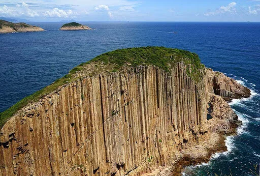
High Island, known in Chinese as Leung Shuen Wan island is a former island in the southeast of Sai Kung Peninsula, Hong Kong. Photo credit: hulutrip.com
Address: High Island, Sai Kung, New Territories
Website: www.geopark.gov.hk
How to get there:
Join the East Dam Half-day Tour, available on Saturdays, Sundays and public holidays. Round-trip itinerary is available. Enquiries: +852 2394 1538 (Volcano Discovery Centre); or
Take bus 94 from Sai Kung town centre or bus 96R (service on Sundays and public holidays only) from MTR Diamond Hill Station. Get off after Pak Tam Chung and walk along Tai Mong Tsai Road to the junction ahead. Turn right on Man Yee Road and walk about 9 km; or
Take a taxi from Sai Kung town centre or Pak Tam Chung to the High Island Geo Trail.