
Hong Kong UNESCO Global Geopark
You don’t have to be a rock buff to enjoy the Hong Kong UNESCO Global Geopark. Located in the East and Northeast New Territories, the park includes the Sai Kung Volcanic Rock Region and the Northeast New Territories Sedimentary Rock Region and showcases Hong Kong’s timeless and eerily beautiful landforms.
Tips
Many island or coastal landforms in the Geopark are best viewed from a boat. In areas with loose and slippery rocks it is best not to go ashore. Also, to protect these landforms, please don’t climb or make any kind of markings on the rocks. Get more out of your visit by joining a guided tour and reading the Geopark information online before departing.

In September 2011, UNESCO listed the Hong Kong Geopark as part of its Global Geoparks Network. Photo credit: hulutrip.com

Volcano Discovery Centre
Hong Kong UNESCO Geopark Volcano Discovery Centre conveniently located at Sai Kung Waterfront Park offers comprehensive information to advise visitors the best way to explore the Geopark. For more information, click here.
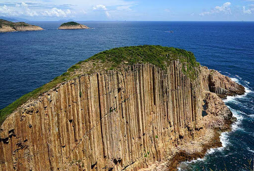
High Island
The easiest location to view the park’s remarkable geological heritage is High Island. From here, the hexagonal volcanic columns are visible along the coast, as is the rock column wall near the East Dam of High Island Reservoir. For more information, click here.

Sharp Island
Sharp Island is an important relic of an ancient supervolcano that erupted more than 140 million years ago. The island is covered by rocks formed from volcanic fragments and magma. For more information, click here.

Ung-Kong-Group
The Ung Kong Group consists of Bluff Island, Wang Chau and Basalt Island. The forces of sea and wind have helped develop numerous steep cliffs and sea arches on the southeast coast of the islands, including the 30-metre-high sea arch at Wang Chau, the 45-metre-high sea arch at Basalt Island, and the Tiu Chung Arch at Jin Island. For more information, click here.

Ninepin Group
The Ninepin Group is made up of South Ninepin Island, North Ninepin Island, and East Ninepin Island, along with several small rock islets. North Ninepin Island has the most eye-pleasing abrasion landforms with hexagonal rock columns overspread with joints formed by geological movements. For more information, click here.

Double Haven
Rising sea levels 6,000 to 8,000 years ago submerged the river valleys in Double Haven, leading to the formation of indented shorelines with headlands and bays. But the mountains in the area were mostly formed some 160 million years ago, when lava mixed with volcanic ash formed rock strata. For more information, click here.

Tung Ping Chau
Crescent-shaped Tung Ping Chau, Hong Kong’s easternmost island, has long been popular with locals for its picturesque rock formations. It boasts the youngest rocks in Hong Kong — merely 55 million years of age, give or take! For more information, click here.

Port Island & Bluff Head
China Danxia — a name for red-coloured landforms specific to China — was included on the UNESCO World Heritage List in 2010, and Port Island has a similar rock formation of these rare geological landforms in a seascape setting. Rich iron oxide gives the island’s sandstone and siltstone a bright red hue. For more information, click here.

Tolo Channel
The oldest rocks in Hong Kong are found along the north coast of Tolo Channel. Ma Shi Chau located west of the channel, features sedimentary rocks formed some 280 million years ago which are the second oldest in Hong Kong. For more information, click here.