Peak Circle Walk | 3.5km | Easy

The top thing to do in Hong Kong is to take in the world-famous vista of Victoria Harbour from The Peak. Some of the best views are on the Peak Circle Walk, which winds around the highest point on Hong Kong Island.

Did you know?
There is more than one way to circle a peak. Do this walk in reverse, starting around 90 minutes before sunset, and you’ll be looking at Hong Kong Island’s scenic south side in the glow of afternoon light. You’ll be coming around to the north side, with views of the harbour, at just the right time, when twilight gives way to night and the city becomes a galaxy of shimmering lights.

The Peak Circle Walk loops around the highest point on Hong Kong Island, ensuring the best views from every angle. Photo credit: travelvui.com

The Peak Circle Walk loops around the highest point on Hong Kong Island, ensuring the best views from every angle. Photo credit: travelvui.com

Starting Point

Hello Hong Kong Hike Guide Peak

*Photos were taken before after the Peak Tram renovation.

Photo credit: Jamie of J3PrivateTours

From MTR Central Station, take the steps at Exit J2, or take Exit K which has escalators and leads directly into Statue Square. Walk to the lower Peak Tram terminus located on Garden Road for the scenic ride up to The Peak. Alternatively, you can take bus 15 from Exchange Square bus terminus, or minibus 1 from MTR Hong Kong Station public transport interchange. The Peak Circle Walk begins at Lugard Road near the Peak Tower.

Lugard Road

Hong-Kong-Tour-Lugard-Road-Lookout.jpg

Built in 1913–14, this road is named after Hong Kong’s 14th governor, Sir Fredrick Lugard. The sections that are narrow, cliff-side paths are called ‘plank roads’. After about 20 minutes, you’ll arrive at the Lugard Road lookout, which offers a spectacular panoramic view of Victoria Harbour. Photo credit: dailytravelpill.com

Harlech Road

Hong-Kong-Tour-Agency-Harlech-Road-Waterfall.jpg

Lugard Road runs into Harlech Road, which will slowly take you back to The Peak Tower and to the end of your lap around The Peak. It takes about 15 minutes to traverse the entire tree-shaded path, or a bit longer if you stop to appreciate the waterfall falling below Mount Austin Playground. Watch out for those joggers rushing past: Harlech Road is one of their favourites. Photo credit: hk-victoria-peak.com

End Point

Hong-Kong-City-Tour-The-Peak-Tower.jpg

The walk will take you back to its starting point near The Peak Tower. From here you can catch the Peak Tram, bus 15 or minibus 1 back down to Central. Photo credit: thepeak.com.hk

Lung Fu Shan Country Park

Hong-Kong-Local-Tours-Lung-Fu-Shan-Country-Park.jpg

Take it farther! If time and energy are on your side, you can turn this leisurely stroll into a substantial walk to Lung Fu Shan Country Park. For something more in between, you can head to Pinewood Battery by turning right onto Hatton Road at the intersection of Lugard and Harlech roads. From here, take a tour of the University of Hong Kong and return to Central on bus 13 from Kotewall Road. Photo credit: flickr.com


Click here for a better resolution of The Peak map.

Info:
Area:
The Peak, Hong Kong Island
Starting point: Lugard Road
Endpoint: Harlech Road
Average hiking time: About 1.5 hours
Distance: 3.5 km
Replenishing stations: There is no replenishing station along the route. So before starting out, fuel up at a restaurant or stock up at a store in The Peak Galleria or The Peak Tower.
Difficulty: Easy


With thanks to the Hong Kong Tourism Board and discoverhongkong.com for the content.

Dragon's Back | 8.5km | Moderate

The last leg of the Hong Kong Trail, this meandering path on the ridge of Dragon’s Back is widely hailed as one of Hong Kong’s best urban hikes. Besides its attractive name, Dragon’s Back has a sightseeing platform near the peak that provides truly spectacular views of southern Hong Kong Island and its shoreline. Right at the trail’s end is Big Wave Bay. Take a dip or surf the waves for a relaxing finale to this hike.

It is arguably the best hike on Hong Kong Island. Photo credit: traveller.com.au

It is arguably the best hike on Hong Kong Island. Photo credit: traveller.com.au

Shek O Peninsula Viewing Point

Hong-Kong-Day-Tours-Shek-O-Peninsula-Viewing-Point.jpg

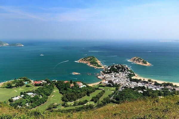
From Shek O Road, you will first walk through a shaded path onto this section of the Hong Kong Trail. About a minute into your hike, the path will open up to the sky as you ascend. After 20 minutes or so, you’ll find yourself on the Shek O Peninsula Viewing Point overlooking Shek O Beach on the foot of the hill, and also the two isles off Shek O Peninsula. Photo credit: canon.com.hk

Shek O Peak

Tours-in-Hong-Kong-Dragons-Back-Shek-O-Peak.jpg

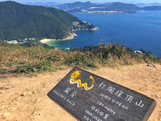
Although bare and exposed, the platform on the summit of Shek O Peak (284 m) is the perfect place to take in the panorama of the peninsula’s coastline. When you turn around to observe the winding trails, you’ll finally see how Dragon’s Back got its well-deserved name. Photo credit: themcnuggetsqueen.com

Dragon’s Back & Pottinger Gap

Hong-Kong-Walking-Tours-Dragons-Back-Pottinger Gap.jpg

Stay on the rolling ridge to trace the “dragon” while you climb uphill. Stop at the Dragon’s Back Viewing Point for a great view of the Tai Tam Bay west of Shek O Peninsula. On a clear day, even Lamma Island, to the southwest of Hong Kong Island, is visible from the deck. Once over the ridge, you'll arrive at Pottinger Gap. Here you get a view of Chai Wan’s urban high-rises against a forested landscape. Photo credit: walkonhill.com

Big Wave Bay

Tours-in-Hong-Kong-Big-Wave-Bay.jpg

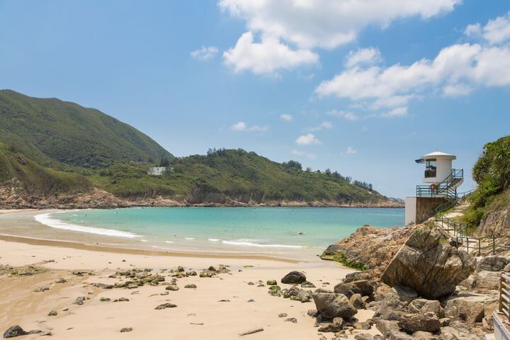
After passing a pavilion, you’ll begin a sharp descent on an uneven stone and dirt path. This very last stage of the trail is mostly shaded and can be slippery at times. Once you’ve exited the trail and cleared the village houses, a beach popular with surfers lies waiting. Big Wave Bay will greet your arrival with shimmering white waves against the blue sky. Photo credit: thetraveler.net

Trip ideas: If you plan on watching the sunrise or sunset on Dragon’s Back, check the Hong Kong Observatory website for the exact times: www.hko.gov.hk


Click here for a better resolution of the Dragon's Back’s trail map.

Info:
Area:
Southern District
Starting point: Shek O Road near To Tei Wan Village
Endpoint: Big Wave Bay
Average hiking time: 4 hours
Distance: About 8.5 km
Refuel: There are no refueling stops along the trail.
Difficulty: Moderate
Most of the route is on dirt paths. The first half has very little shade, and there is also a steep 200-meter-long uphill stretch. The flight of descending stone steps in the last section is quite steep, too.


How to get there:

To the starting point:
From MTR Shau Kei Wan Station Exit A, walk to the Shau Kei Wan Bus Terminus. Take bus 9 or the red minibus with the sign “Shek O” to the To Tei Wan stop on Shek O Road.

From the endpoint:
Take the red minibus with the sign “Shau Kei Wan” or a taxi from Big Wave Bay back to Shau Kei Wan.


With thanks to the Hong Kong Tourism Board and discoverhongkong.com for the content.

Red Bean Soup Recipe

 Red bean soup is a popular Chinese dish served in Mainland China, Hong Kong, and Taiwan. In Cantonese cuisine, it is commonly served as a dessert - Hot during winter and Cold during summer which is a very popular dessert in local Chinese restaurants. Feel free to ask your Hello! Hong Kong tour guide to add it to your itinerary!

If you have a sudden craving for this sweet dessert, below is an easy to make a recipe that you can do at the comforts of your home.

iNGREDIENTS

  • 10 ounces red (Azuki) beans

  • 1/2 teaspoon vanilla extract

  • 1 cup sugar

  • 8 cups water

  • 1 orange

    PROCEDURE

  • Put beans in a slow cooker (Crockpot)

  • Add water and sugar, and mix well.

  • Turn heat to high

  • Close lid and let it cook for 8 hours

  • Open lid.

  • Add vanilla extract and mix well.

  • Add orange.

  • Close lid again and let it cook for 20 minutes.

  • Open lid and remove orange.

  • Turn off heat and serve on small bowls.

Photo credit: ChinaSichuanfood   Taste this delicious red bean soup dessert on your Hello! Hong Kong Tour

Photo credit: ChinaSichuanfood

Taste this delicious red bean soup dessert on your Hello! Hong Kong Tour

Now, you can enjoy your homemade Red Bean soup! You may also put a little twist to it by adding sago, coconut milk, ice cream, glutinous rice balls, or purple rice. Happy Snacking!

Recipe and procedure credits to simplecookingstudio.com

Repulse Bay Beach

Primarily an upmarket residential area, sun-drenched Repulse Bay has a relaxed resort-like feel to it. Its wide, wave-lapped beach is popular with both locals and visitors and is great for strolls in the early morning, daytime sun-soaking when the bathers are out in force, or lingering at sunset when all has turned mellow.

This crescent-shaped stretch of sand is one of the most beautiful beaches in Hong Kong. It is also home to the Hong Kong Life Saving Society clubhouse, which is built in traditional Chinese style, with a ceiling decorated with magnificent swirling dragons. Towering twin statues of the deities Kwun Yam and Tin Hau dominate the picturesque gardens that lead down to the beach.

The nearby colonial-style building, The Repulse Bay houses designer shops and award-winning restaurants and resembles the luxury hotel built in 1920 that originally occupied the site. Most of its grounds were redeveloped into luxury apartments more than 20 years ago, and only the original arcade remains.

Please check the latest information on public beaches here.

The beach was extended artificially, and thus the sand closer to the shore is coarser in texture than the sand further away. It is one of the longest beaches in Hong Kong. Photo credit: uk.hotels.com

The beach was extended artificially, and thus the sand closer to the shore is coarser in texture than the sand further away. It is one of the longest beaches in Hong Kong. Photo credit: uk.hotels.com

Address: Beach Road, Repulse Bay, Hong Kong Island
Telephone: +852  2812 2483
Website: www.lcsd.gov.hk

How to get there:

  • Bus 6, 6A, 6X, 66 or 260 from Exchange Square bus terminus (near MTR Hong Kong Station, Exit D) and alight at Repulse Bay Beach.


With thanks to the Hong Kong Tourism Board and discoverhongkong.com for the content.

Cheung Sha Beach and Pui O Beach

When it comes to beautiful beaches, the village of Pui O can boast two contenders: Cheung Sha Beach, one of Hong Kong’s longest; and Pui O Beach. Head to either one for a cooling dip, to make some new friends, or to just chill on the sand for a few hours. There are also a few eateries nearby, so you can stick around for the sunset with a contented stomach.

Please check the latest information on public beaches here.

Pui O Beach has a very relaxed, laid back vibe and Cheung Sha Wan is one of Hong Kong's longest beaches. Photo credit: thetraveler.net

Pui O Beach has a very relaxed, laid back vibe and Cheung Sha Wan is one of Hong Kong's longest beaches. Photo credit: thetraveler.net

Address: South Lantau Road, Lantau Island, Outlying Islands
Telephone: +852  2984 7675 (Pui O Beach), +852 2980 2114 (Cheung Sha Beach)
Website: www.lcsd.gov.hk

How to get there:

  • Cheung Sha Beach:
    Ferry from Central Pier 6 to Mui Wo (fast ferry services take 35–40 minutes and ordinary ferry services take 50–55 minutes). Then take bus 1 to Pui O Beach (about 15 minutes) or bus 1 or 2 to Cheung Sha Beach (about 25 minutes).

  • Pui O Beach:
    Ferry from Central Pier 6 to Mui Wo (fast ferry services take 35—40 minutes and ordinary ferry services take 50—55 minutes). Then take bus 1 to Pui O Beach (the bus journey takes about 15 minutes).


With thanks to the Hong Kong Tourism Board and discoverhongkong.com for the content.

Hung Shing Yeh Beach

Hung Shing Yeh Beach’s clean water and powdery sand have been attracting expats and locals for a long time. It’s also a top spot to ring in yet another laid-back evening on the sand by throwing (or maybe even crashing) a party in the barbecue area, as the sunset’s rays reflect off the water.

Please check the latest information on public beaches here.

A 25-minute walk southeast (1.7km) from the Yung Shue Wan ferry pier, Hung Shing Yeh beach is the most popular beach on Lamma. Photo credit: jonistravelling.com

A 25-minute walk southeast (1.7km) from the Yung Shue Wan ferry pier, Hung Shing Yeh beach is the most popular beach on Lamma. Photo credit: jonistravelling.com

Address: Yung Shue Wan, Lamma Island, Outlying Islands
Telephone: +852  2982 0352
Website: www.lcsd.gov.hk

How to get there:

  • Take a ferry from Central Pier 4 to Yung Shue Wan (approximately 30 minutes). From the Yung Shue Wan Pier turn right and walk along the Family Trail to the beach for about 30 minutes.


With thanks to the Hong Kong Tourism Board and discoverhongkong.com for the content.

Mui Wo and Silver Mine Bay Beach

Silver Mine Bay Beach in Mui Wo is named after the area’s alternative name — Silver Mine Bay. The Mui Wo Valley was first settled by farmers around the middle of the Ming dynasty (16th century). By the 19th century, there were six villages in the valley, many of whose inhabitants worked in a silver mine that operated for several decades. Remnants of the mine can still be seen. Also surviving to this day are several watchtowers built by the villagers to protect themselves from pirate attacks.

By the 1930s the pirates had gone and the beach became popular with swimmers and weekend visitors to the nearby hotel. More recently, the villages in this area have attracted urbanites looking for a quieter life.

Close to the pier and bus terminus you can check out the market and find a good selection of Chinese and international restaurants, a no-frills seaside dining arcade, and seaside eating places specialising in noodles, seafood and duck.

Mui Wo is an ideal launching pad to explore other parts of Lantau Island, including the famous Big Buddha and Po Lin Monastery and the stilt houses of Tai O Village.

Please check the latest information on public beaches here.

One of the most convenient beaches on Lantau Island, long and narrow Silvermine Bay is located just a few minutes' walk from the Mui Wo ferry pier. Photo credit: leasing-riverwalk.azurewebsites.net

One of the most convenient beaches on Lantau Island, long and narrow Silvermine Bay is located just a few minutes' walk from the Mui Wo ferry pier. Photo credit: leasing-riverwalk.azurewebsites.net

Address: Tung Wan Tan Road, Mui Wo, Lantau Island, Outlying Islands
Telephone: +852  2984 8229 (Silver Mine Bay Beach)
Website: www.lcsd.gov.hk

How to get there:

  • Catch a ferry from Central Pier 6 to Mui Wo. Fast ferries take around 35–40 minutes; ordinary ferries take around 50–55 minutes.

    Silver Mine Bay Beach:
    Walk for 15 minutes from Mui Wo Ferry Pier. Turn right at the pier and go to Mui Wo Ferry Pier Road, then walk to Ngan Kwong Wan Road. Walk along Ngan Shek Street to Tung Wan Tau Road to the beach.


With thanks to the Hong Kong Tourism Board and discoverhongkong.com for the content.

Tung Wan Beach and Kwun Yam Beach

On the weekends, surf-loving city dwellers head to the island of Cheung Chau to enjoy the beaches where an Olympic windsurfing champion once trained. Lee Lai-shan (or ‘Shan Shan’ as she is affectionately known locally) brought back Hong Kong’s first Olympic gold medal from the Atlanta Games in 1996.

A year-round favourite with locals is Tung Wan Beach, which has turquoise waters and charming night views of Aberdeen and Lamma Island. In a small nearby garden, a sculpture of a windsurfer commemorates Shan Shan’s achievement. Right next door to Tung Wan Beach, Kwun Yam Beach is where the young windsurfer with stars in her eyes cut her teeth. The Cheung Chau Windsurfing Centre here provides windsurfing, surfing and canoeing equipment, and it’s possible to see unusual coastal rock formations and the Mini Great Wall from the waters around here.

Please check the latest information on public beaches here.

Hong Kong’s first Olympic gold medallist trained here for the windsurfing event. Photo credit: beasbites.wordpress.com

Hong Kong’s first Olympic gold medallist trained here for the windsurfing event. Photo credit: beasbites.wordpress.com

Address: Cheung Chau Beach Road and Hak Pai Road, Cheung Chau, Outlying Islands
Telephone: +852  2981 8389 (Tung Wan Beach), +852 2981 8472 (Kwun Yam Beach)
Website: www.lcsd.gov.hk

How to get there:

  • Ferry from Central Pier 5 to Cheung Chau (fast ferry services take 35–40 minutes and ordinary ferry services take about 55–60 minutes). From the Cheung Chau Ferry Pier, walk along Tung Wan Road for approximately 10 minutes until you reach Tung Wan Beach.

    Kwun Yam Beach:
    Walk around another five minutes from Tung Wan Beach in the direction of Warwick Hotel.


With thanks to the Hong Kong Tourism Board and discoverhongkong.com for the content.

HELLO! HONG KONG TOP PICK | Big Wave Bay Beach, Shek O

A hit with local windsurfers, Big Wave Bay Beach is located at the scenic eastern end of Hong Kong Island, close to the Dragon’s Back hiking trail.

It’s also home to a prehistoric rock carving that is now preserved as a Declared Monument. Remaining undiscovered until a police officer stumbled upon it in 1970, the rock carving shows geometric designs and animals, and is one of many similar carvings found around coastal areas of Hong Kong. These cultural art works reinforce how much Hong Kong’s early inhabitants must have depended on the sea.

Eateries surrounding the beach provide light refreshments.

Please check the latest information on public beaches here.

Often living up to its name, Big Wave Bay has a good beach with clean sands and is a popular surfing beach. Photo credit: thetraveler.net

Often living up to its name, Big Wave Bay has a good beach with clean sands and is a popular surfing beach. Photo credit: thetraveler.net

Address: Big Wave Bay Road, Shek O, Hong Kong Island
Telephone: +852  2809 4558
Website: www.lcsd.gov.hk

How to get there:

  • MTR Shau Kei Wan Station, Exit A3. Take bus 9 to Big Wave Bay Beach.


With thanks to the Hong Kong Tourism Board and discoverhongkong.com for the content.

Hong Kong Park

An oasis of green in an urban setting, Hong Kong Park is outstanding in the way its design blends in with the surrounding natural landscape. The park features an aviary, a greenhouse, the Flagstaff House Museum of Tea Ware, the Hong Kong Visual Arts Centre, fountains, lily ponds, playgrounds, a restaurant and even a marriage registry. The aviary features more than 80 species of birds in a well-designed tropical ‘rainforest’.

Also noteworthy is the way flowing water has been employed as a thematic motif to link the different features of the park by waterfalls, streams, ponds and cliffs made from artificial rocks. The park is also a great vantage point to take some snaps of the surrounding skyscrapers.

Morning Bird-Watching at Hong Kong Park
Join one of the free guided bird-watching walks held every Wednesday by the Leisure and Cultural Services Department and the Hong Kong Bird Watching Society. You can find more information here.

Opened in May 1991, Hong Kong Park was built at the upper half of the former Victoria Barracks Planning Committee. Photo credit: blog.virginatlantic.com

Opened in May 1991, Hong Kong Park was built at the upper half of the former Victoria Barracks Planning Committee. Photo credit: blog.virginatlantic.com

Address: 19 Cotton Tree Drive, Central, Hong Kong Island
Telephone: +852  2521 5041
Website: www.lcsd.gov.hk

How to get there:

  • MTR Admiralty Station, Exit C1. Follow the signs up the escalator to Hong Kong Park.


With thanks to the Hong Kong Tourism Board and discoverhongkong.com for the content.