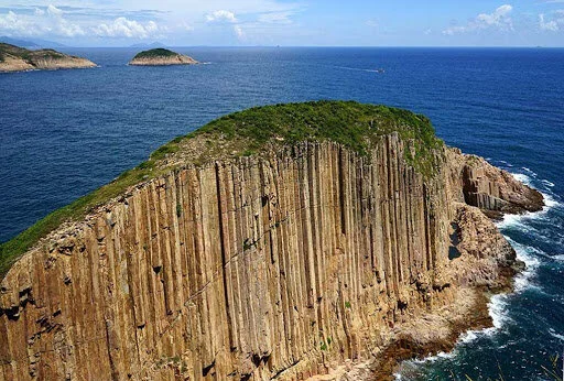

China Danxia — a name for red-coloured landforms specific to China — was included on the UNESCO World Heritage List in 2010, and Port Island has a similar rock formation of these rare geological landforms in a seascape setting. Rich iron oxide gives the island’s sandstone and siltstone a bright red hue. The rocks at Bluff Head were formed by deposits at estuarine deltas about 400 million years ago, and became vertical under the influence of geological movements. Furthermore, weathering and coastal erosion resulted in some peculiar rocks, most notably the ‘Devil’s Fist’.

This island consists mostly of reddish rocks, and exposes some interesting geological features. Photo credit: discoverhongkong.com
Address: The mouth of Tolo Harbour, Tai Po, New Territories
Website: www.geopark.gov.hk
How to get there:
Port Island is difficult to get to on your own. You have to hire a boat to get there.